

Planning a day trip
Pick a destination and a departure time, set your boat speed, and see the wind at each waypoint, when you arrive, and whether you beat last light.
Also known as: cruising, day trip, passage, catalina, two harbors, avalon, king harbor, malibu, paradise cove, how long will it take, distance, eta, last light, departure, boat speed, waypoints
The Cruising tab answers a specific question: if I leave at this time at this speed, what wind will I actually get, and do I make it in before dark?
Planning one
-
Tap Cruising. Local Routes is the first segment.
-
Pick a Route. From Marina del Rey: King Harbor, Malibu Pier, Paradise Cove, Two Harbors and Avalon.
-
Pick a Departure: Now, +1 hr, +2 hr, +3 hr, 7 AM or 9 AM. The clock options mean the next time it comes round, so after nine in the morning, 9 AM means tomorrow.
-
Set Boat speed with the minus and plus buttons, from 3 to 9 knots in half-knot steps. Use the speed you actually average, not your hull speed.
Reading the answer
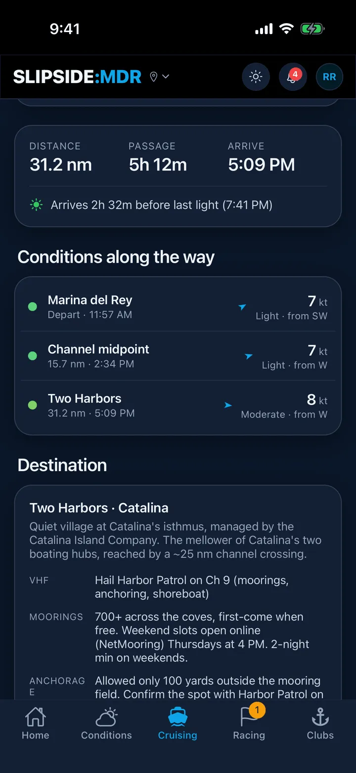
The summary card gives DISTANCE in nautical miles, PASSAGE as hours and minutes, and ARRIVE as a clock time. Under it, the line that usually decides the day: Arrives 1h 20m before last light (7:32 PM), or Arrives after dark. Last light was 7:32 PM.
Below that, Conditions along the way lists each waypoint with how far along it is, when you would be there, and the wind forecast for that hour at that point. That is the useful part: it is not the wind now, it is the wind you will meet when you get there. A waypoint outside the forecast area reads offshore instead of a number.
Last comes the Destination guide: moorings, fuel, guest docks, VHF channels and the local cautions for where you are going.
What it is and is not
Distances are straight lines between turning points and the passage time is simply distance divided by your speed. There is no current, no tide, no leeway and no tacking angle, so a beat to windward will take longer than it says.
The footer says it plainly, and it is worth repeating here: Planning aid only, not for navigation. Use it to decide whether today is the day, then plan the passage properly on a chart.
Where the wind comes from
The same forecast model as the rest of the app, sampled across a grid over the bay and the channel. When the tab is showing a cached copy after an outage, a small Forecast as of badge appears near the top.
Still stuck? In the app, open Profile, then Help & Support, and use Send to support. Otherwise email support@slipside.app.